
We’ve had a lot to say about the super giant worst-ever El Niño building up in the eastern tropical Pacific. Starting with it being a weather phenomenon that for millions of years occurred naturally but now is all our fault. And this year’s was gearing up to be a very mighty wind, warming the hearts of alarmists everywhere who are still smarting over the lack of hurricanes. Thus for instance Bloomberg Green chortled on October 23 that “Berkeley Earth expects the impacts of a strong El Niño to push global temperatures to a new record this year, surpassing 2024,” the hope for glorious disaster being that “El Niño has reached record strength on the conventional Niño 3.4 index, and its peak is still expected later this year.” Alas, it looks like El Niño has let them down too, fizzling out ahead of schedule. According to climatologist Cliff Mass, “The very strong El Niño appears to have hit its peak earlier than predicted a few months ago, suggesting a substantial weakening later this autumn and winter.” Sea Surface Temperatures across the El Niño region haven’t budged since the start of October, and upstream in the so-called Niño 4 region, temperatures are already back to normal. So a not-so Merry Christmas for alarmists.
The holiday reference is, of course, a nod to the origins of the weather phenomenon’s name, which is Spanish for “little boy”. And not just any little boy in this case but the Christ child, reflecting the tradition that every few years warm winds would blow over the South American coast at Christmas time, offering a pleasant break from the normal freezing and storms, for which the locals were grateful to God because in those pre-enlightenment days warm weather was considered a blessing, whereas now we know better.
Or do we? In the topsy-turvy world of alarmism warm winters are now once again a blessing, this time for alarmists who want to keep the public in a state of perpetual alarm. So a premature fizzling of El Niño is like a lump of coal in the stocking of the greens. And it’s what is going on. Have they been naughty in how they handle data or something?
So it seems. Mass shows the SST profile for the Nino 4 region, the western reach of the tropical Pacific:
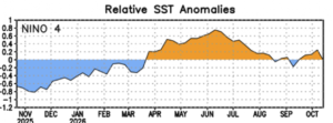
After peaking in June they rapidly tapered off and went below normal by mid-September. Meanwhile NOAA is predicting the centre of the El Niño region, called Niño 3.4, will collapse quickly in the early winter, reaching neutral conditions by April or May:
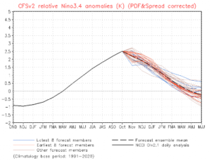
But Mass also points out that El Niño forecasts are very uncertain including these latest ones. Still, the experts should have finalized their forecasts for winter 2027 by sometime in late summer 2027. The only thing they will agree on before then is that whatever happens it was your fault.
