In our continuing travels through Canadian weather records based on the weatherstats.ca website, today's destination is Halifax NS. Last weekend was rather hot there, with temperatures going above 30C, which they don't often do. In this day and age of climate emergencies and panic over warming, one naturally wonders if this is a sign of the apocalypse. If so, it's a very obscure one. So far this decade (counting 0-9, so there are only a few months left in the current one) there have been only 16 days with temperatures over 30C. Last decade there were 21. And guess which decade had 24?
If you guessed the 1940s you were correct. Other decades had fewer. For instance there were only 5 in the 1950s and 6 in the 1980s. There were probably a lot in the 1930s but sadly the records don't go back that far.
If any decade deserves the "climate emergency" label in Halifax it's probably the 1940s. The all-time record for total annual precipitation was set in 1948, as was the record for the most number of days with more than an inch of rainfall. Windiness data only goes back to the 1950s, and since it's been downhill since then the 1940s were probably worse. Looking at the annual maximum wind speed (blue line) and average (green line), other than 2007 there seems to be a slight but steady tendency towards milder winds in Halifax since the early 1950s.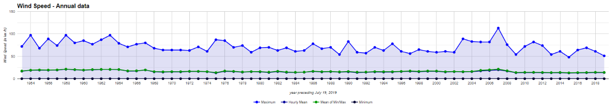
The temperature record also stubbornly refuses to be as terrifying as it's supposed to be. The blue line is the annual maximum, the black line is the annual minimum, and the green line is the annual average. Behold the drama from 1939 to the present: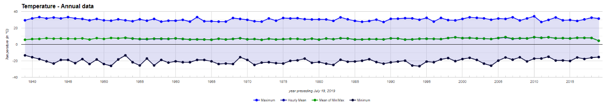
The warmest maximum was in 2010. The coldest maximum was in 2011. The warmest minimum was in 1953. The coldest minimum was in 1994.
Did you spot the climate emergency? Neither did we.


Check out (The Very Real Climate Crisis of 1936 - YouTube by Tony Heller)