According to the world’s top scientists the Arctic will be ice free by the year 2000. No wait, maybe 2004. Er, try 2008. Or it could be 2012. Or 2013, or if not then definitely 2015, 2016, or 2017, otherwise 2044 for sure. Alternatively, if instead of listening to endless guesswork by the world’s top scientists, as selected by the media, themselves or both, you’d just like to see the data for yourself, for both the North and South Poles, Professor Ole Humlum has it all laid out for you on the sea ice charts at climate4you.com.
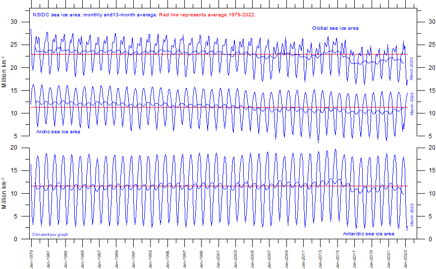
The chart looks like this:

The top line is the global total, the middle line is Arctic sea ice area and the bottom line is Antarctic sea ice (NB not land ice), in each case from 1979 to the present. The middle line shows that up to about 2013 there was a downward trend in the Arctic, which no doubt contributed to the run of predictions of the North Pole’s imminent demise, but since then the average has leveled off. The sawtooth pattern clearly illustrates the important point that the ice melts back every summer and then re-freezes in the winter. The annual cycle is far larger than the small changes in the average over time.
It’s especially true at the South Pole, which is the bottom graph. There we get no trend at all, just the cycle of the seasons. Global warming is supposed to be melting the ice at both poles, yet Antarctica stubbornly refuses to do as it’s told.
Adding up both hemispheres gives us the top line. Current global ice extent is a little below the 1979-2022 average, but it wasn’t that long ago (2015-16 in fact) when it was a bit above average. You can extrapolate the lines forward just as well as the experts if you want. And if you announce your forecast and it turns out to be wrong, don’t worry, just wait a year and make another one.
Provided it’s of imminent disaster, no one will fact check you. Except us.


Isn't it true that the Arctic and big swaths of Antarctica have been ice free for long periods? There's coal there! There's also areas that have never been ice free.
Greenland sediment cores indicate Boreal forests of Ash, Birch and insects.
"researchers infer that Greenland’s temperature once varied from 50 degrees Fahrenheit in summer to 1.4 degrees Fahrenheit in winter."
Admitted pure supposition, but after looking at live world shipping maps some nights, I'd speculate that the hoards of ships around the Antarctic peninsula may have an ice melting factor. All that hot water for the summer tourist season must have some impact, surely? Even just moored, ship loads of heat is generated just to keep the ship going.